Back كالفرتون (ماريلند) Arabic کالورتون، مریلند AZB Calverton (Maryland) Catalan Calverton (lungsod sa Tinipong Bansa, Maryland) CEB Calverton (Maryland) Spanish کلورتون، مریلند Persian کلاورتن (مريلند) GLK Calverton (Maryland) Italian Калвэртон (Мэриленд) Kazakh Калвэртон (Мэриленд) Kirghiz
Calverton, Maryland | |
|---|---|
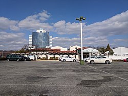
 The Villa and Calverton Tower in March 2018 | |
 Location of Calverton, Maryland | |
| Coordinates: 39°03′28″N 76°56′56″W / 39.05778°N 76.94889°W | |
| Country | |
| State | |
| Counties | |
| Area | |
| • Total | 4.60 sq mi (11.90 km2) |
| • Land | 4.58 sq mi (11.85 km2) |
| • Water | 0.02 sq mi (0.05 km2) |
| Elevation | 289 ft (88 m) |
| Population (2020) | |
| • Total | 17,316 |
| • Density | 3,784.09/sq mi (1,461.08/km2) |
| Time zone | UTC−5 (Eastern (EST)) |
| • Summer (DST) | UTC−4 (EDT) |
| Postal code(s) | 20904, 20705 |
| Area code(s) | 301, 240 |
| FIPS code | 24-12350 |
| GNIS feature ID | 2389269[2] |
Calverton is an unincorporated area and census-designated place located on the boundary between Montgomery and Prince George's counties, Maryland, in the United States.[3] as of the 2020 census, it had a population of 17,316.[4]
- ^ "2020 U.S. Gazetteer Files". United States Census Bureau. Retrieved April 26, 2022.
- ^ a b U.S. Geological Survey Geographic Names Information System: Calverton, Maryland
- ^ U.S. Geological Survey Geographic Names Information System: Calverton, Maryland
- ^ "Calverton CDP, Maryland". United States Census Bureau. Retrieved March 13, 2022.